Property Records Don't Match? Check Parcel IDs, Acreage, and Maps
A practical way to work through conflicting property information without guessing which record is right.
When property records disagree, first match the property and identifiers. Keep each value with its source, label, and date. Ask the responsible office to explain the difference, and get professional review when it affects your purchase, boundary, or intended use.
The listing says five acres. The assessor's page shows something different. The map has another number entirely.
Before deciding which one to believe, check what each record describes. You may be comparing different parcels, different kinds of acreage, or records collected at different times.
Start here: match the location and identifiers, keep each value with its original label and source, and ask the office responsible for the record to explain the difference. If the answer could change your purchase, boundary, or building plan, get the appropriate professional review before relying on it.
You don't have to solve every discrepancy yourself. You do need to know which question is still open.
1. Make sure you're comparing the same property
Start a simple property note with:
- State and county, plus the town or city when it maintains the records.
- Parcel number exactly as displayed, including letters and leading zeros.
- Any separate account number, map-and-lot number, or identifier linking the map and assessment databases.
- Property address or location, nearby roads, and the record's map link.
- Every parcel included in the proposed sale.
Keep the labels with the numbers. An assessment account, a mapped parcel, and an identifier used to connect two databases can serve different purposes. Don't replace one with another just because it looks more complete.
Boulder County's assessor data guide provides a concrete example: it distinguishes an account number from a parcel number and explains that some parcels have multiple accounts. That is one county's structure, so check the definitions used where your land is located.
Compare the mapped location as well as the text. A matching street name alone is weak evidence, especially when the listing uses a nearby address or the property has no assigned street number.
If you still have two possible matches, keep both as candidates. Ask the assessor or GIS office which record corresponds to the land and documents you have. Avoid carrying a guessed match into the rest of your research.
Need help finding the first record? Start with the County GIS Finder or the Research Hub.
2. Ask what each acreage number measures
The word “acres” can hide important differences.
| Where you found the number | What to check before using it |
|---|---|
| Property listing | Which parcels are included, where the number came from, and whether it is rounded |
| Assessor or property card | The exact field label, units, record date, and whether it refers to the whole parcel or part of an account |
| GIS map | Whether the number was calculated from the mapped shape or copied from another record |
| Deed, plat, or survey | Which land the document describes, its date, and whether later documents affect it |
GIS-calculated area comes from the digital parcel shape. It should not be silently substituted for an acreage value reported in another record. Boulder County expressly warns that its GIS acreage is not survey quality and may differ from other recorded figures. Read its field definitions.
Save the values separately, using descriptions such as “listing acreage,” “assessor-reported acreage,” and “GIS-calculated acreage” only when the source supports that label.
Don't average the numbers. Don't assume the largest number is what you are buying. And don't use a general percentage tolerance to dismiss a difference that could affect your plan.
Even a resolved total acreage figure leaves other questions open. Setbacks, access, easements, terrain, and water or wastewater requirements still need their own review. Ask the responsible planning office how land area is measured for the approval you need.
3. Check dates and record history
Two official sources can describe the same property without reflecting the same point in time.
Look for:
- The assessment or tax year.
- The date of the document itself.
- The parcel-data collection year.
- The map or record update date.
- A recent split, combination, boundary adjustment, or other recorded change.
A website's recent update date does not establish that every fact on the page was newly checked. Note the date attached to the particular record or field when one is available.
Connecticut illustrates why this matters. CAMA means computer-assisted mass appraisal, the assessment system. The state's Parcel and CAMA guidance distinguishes assessment-data capture dates from parcel-edit dates and says spatial accuracy and completeness vary by municipality and regional council of governments. Statewide and local records may require comparison rather than a quick choice of the newer-looking website.
Ask whether the record you found is current, historical, or part of a pending update. If a seller describes a recent split, request the relevant document reference and ask the responsible office how the new parcels appear in its system. A seller's description alone does not resolve the record history.
4. Treat a blank field as an unanswered question
A blank building field does not, by itself, establish that the land is vacant. A missing document link does not establish that no document exists. An unsuccessful search does not settle the question you were researching.
Read the field definition before interpreting a zero, abbreviation, or empty result. Ask whether the website covers that kind of record and whether another office maintains it.
For example, the West Virginia Property Viewer help explains that some returned records have no matching map geometry. It also describes different sources for address searches and parcel searches. A gap in one result may require another research path.
Write “not found in this source” rather than changing it to “does not exist.” Record where you looked and what you tried so the next person can continue the search.
5. Separate a map problem from a boundary question
An online outline that does not line up neatly with an aerial image deserves attention. The image alone does not tell you which line is correct or establish an encroachment.
Check the parcel selection, map layer, imagery date, and available accuracy notes. Then ask the GIS office whether it knows of a mapping issue. If the question is where a boundary lies on the ground, consult a licensed land surveyor.
For the records behind the map, look for the applicable deed, recorded plat, and available surveys. King County's property-research resources show how parcel maps, assessment reports, recorded documents, and permitting resources connect while serving different functions.
If documents conflict or you need to understand ownership, easement rights, or the legal description in a transaction, involve a title professional or real-estate attorney as appropriate. Ask a surveyor about the scope of work needed to locate boundaries and reconcile the relevant survey evidence.
For more background, read parcel maps versus plat maps and how to find a deed, plat, or recorded easement.
A worked example: three numbers, one open question
Illustrative example only. These are invented figures, not an actual property or LandGauge result.
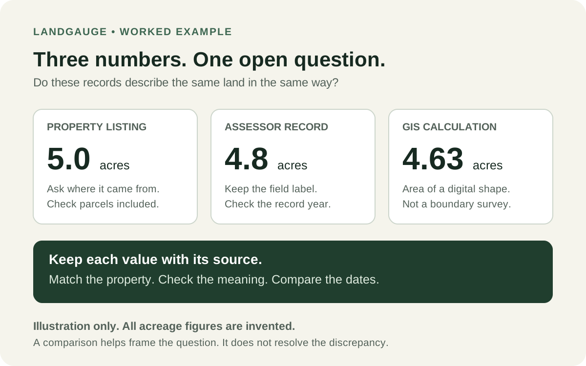
Suppose a listing advertises 5.0 acres, a property card reports 4.8 acres, and a GIS field specifically labeled calculated acreage shows 4.63 acres.
Your first note might read:
- Listing: 5.0 acres. Source of acreage not yet explained. Need confirmation of all parcels included.
- Property card: 4.8 acres. Save the parcel/account identifiers, field label, and record year.
- GIS: 4.63 calculated acres. Save the selected parcel link and map-data date if provided.
- Open question: Do all three describe the same land, and what explains the difference?
- Next action: Ask the assessor/GIS office about the identifiers and acreage fields. Request the relevant deed, plat, or survey references. Get professional review if the discrepancy affects the purchase or intended use.
The useful result is a clear question with evidence attached. Selecting 4.8 because it sits between the other numbers would not answer it.
What to ask the office
Use the official local directory to find the office responsible for the record. Send a focused question with the record links and identifiers:
“I'm researching a property in [county/town], parcel [ID]. The property card reports [value and label], while the GIS record shows [value and label]. Can you confirm whether both records describe the same land, explain what each field measures, and point me to the current record or correction process?”
If relevant, add:
- Does this account include more than one parcel or component?
- Has the parcel number changed after a split or combination?
- Which document or survey reference supports the acreage in this record?
- Does your office handle this question, or should I contact someone else?
For mapping or assessment entries, start with GIS or the assessor. For document copies, use the recorder, clerk, or register of deeds. For development rules, contact the responsible planning office. Names and responsibilities vary locally.
Keep the reply, date, and office with your notes. An explanation of a field is useful evidence about that field; it does not automatically settle your other property questions.
Keep the disagreement visible until it is explained
Use a separate note for each unresolved issue:
- Question: What doesn't match?
- Records: What does each source actually say?
- Dates: Which record years or dates apply, and when did you access the sources?
- Next step: Who can help, and what document or answer is needed?
- Outcome: What was clarified, and what still needs review?
The LandGauge Research Hub helps you find available official resources. The land due-diligence checklist helps you keep the broader questions in view. Availability varies by location, and LandGauge cannot settle a boundary or title dispute for you.
If you use AI to summarize records, check the summary against the originals. Keep the differing values and their sources rather than accepting a single blended answer. An unsupported explanation still needs verification.
Finding a discrepancy is useful progress. You have identified something to resolve before it becomes an assumption in your purchase or building plan.
This guide is educational, not legal, title, surveying, tax, or engineering advice. Official online records may be incomplete or outdated. Confirm the information needed for your specific property and proposed use with the responsible offices and qualified professionals.
Frequently asked questions
Sources & Official Resources
Primary sources that support the information in this guide. Requirements and record systems vary by jurisdiction — always confirm with the agency responsible where the property is located.
- Connecticut GIS OfficeParcel and CAMA
Explains variation in municipal parcel data and distinguishes assessment-data capture from parcel-edit dates. Connecticut example, not a nationwide data standard.
- Boulder County AssessorAssessor Public Dataset documentation
Defines local account and parcel identifiers, multiple-account relationships, and GIS acreage limitations. Definitions apply to Boulder County's dataset.
- King County GIS CenterProperty Research
Separates parcel maps, assessment reports, recorded documents, and permitting resources.
- West Virginia Property Tax Division and WV GIS Technical CenterWV Property Viewer Help
Explains differing search sources, records without matching geometry, and local-assessor follow-up for property-record errors.
Related guides
- GIS & Parcel ResearchParcel Map vs. Plat Map: What's the Difference Before Buying Land?A parcel map identifies a tax parcel. A recorded plat documents how land was divided. Neither one is a survey — here is what each proves and what to verify next.
- GIS & Parcel ResearchHow to Search County Property Records Before Buying LandSearch official county property records by parcel number, confirm the property match, and identify acreage, access, and land-split questions before buying land.
- Due DiligenceHow to Research Land Before Buying: A Practical GuideSame Questions. Different Timeline.
- GIS & Parcel ResearchHow to Find Your Property's Parcel Number, GIS Map, and Land RecordsFind your land's parcel number, county records, and GIS map, then explore zoning and property research with LandGauge's local research resources.