How to Search County Property Records Before Buying Land
Search official county property records by parcel number, confirm the property match, and identify acreage, access, and land-split questions before buying land.
Imagine finding a property with a house and about 30 acres. Your idea is to sell the house on its own lot and divide some of the remaining land into roughly four-acre lots.
Before sketching lot lines or estimating sales, start with the county property record. It helps you identify what you are researching and build a list of questions that need answers. This walkthrough uses Bannock County, Idaho, as an example. The proposed split is a hypothetical learning scenario, not a finding that this property can be divided.
1 Find the official county search
Open LandGauge’s County GIS Finder and select the state and county to find official map sources. For the Bannock County example, the county’s official GIS page provides its parcel-viewer links.
The county is updating its mapping applications and says the older parcel viewer will be discontinued December 31, 2026. The screenshots illustrate the search process; the current viewer may look different. Following the county’s own link helps you reach its current application.
2 Search using the parcel number
The first screenshot shows the Parcel ID search with an identifier entered and an Apply button below. Use the identifier supplied for the property you are considering, preserving its letters, numbers, and any required formatting.
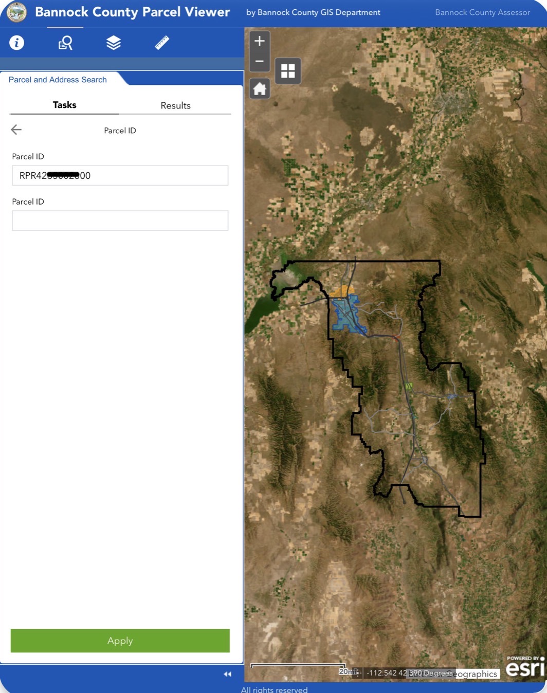
If you get no result, check the identifier and county before trying again. If the viewer offers address or map searches, those may provide another route. Available options differ between counties.
3 Check that the result matches the property
Open the result and compare its mapped location, parcel identifier, and description with the property information you received. Check which parcel or parcels the sale actually includes.
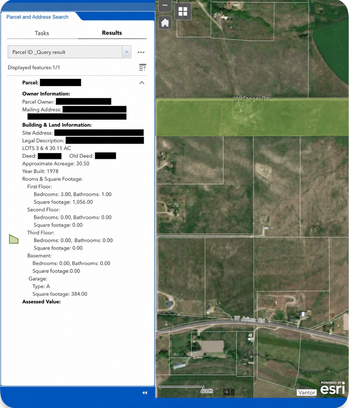
An aerial image helps you orient yourself. It does not, by itself, establish surveyed boundaries, legal access, or permission to divide land.
For the house-and-land scenario, confirm where the house, driveway, and existing services sit relative to the land included in the sale. This screenshot alone does not establish that the house belongs to the highlighted strip.
4 Notice details that need verification
The result lists Approximate Acreage: 30.50, while a separate legal-description line reads 30.11 AC. That difference is a question to resolve with the county and the relevant recorded documents before using an acreage figure in your plan.
The record also lists a year built and building details. Treat these as research leads to compare with the actual property and supporting records. Do not assume every field is current or complete.
5 Turn the four acre idea into questions
Keeping the house on one lot and creating additional lots is a concept to investigate. Dividing the total acreage by four does not establish the number of saleable lots.
Ask the responsible planning office:
- What jurisdiction and zoning apply, and is the proposed division allowed?
- What lot size, frontage, density, and subdivision requirements apply?
- Can the house lot retain the access, setbacks, and services it needs?
- How would each additional lot obtain legal access and suitable water and wastewater service?
- What surveys, reviews, improvements, and approvals would be required?
Bannock County’s Planning and Development office directs people considering a land division to contact its staff. For property within a city, confirm which office has jurisdiction.
Only after defining those constraints should you compare lot scenarios and development costs. Keep the house lot, access needs, and land unavailable for additional lots in your assumptions.
Your next step
Find the record. Confirm the property. Write down what remains unresolved.
Continue with your property: Start your free property check. Enter the property’s address or parcel information, confirm the property match, and continue into Due Diligence Lite to work through the evidence and unanswered questions.
Want to test preliminary split economics? Open the Land Split Calculator. Enter your purchase price, development costs, and projected sale value per lot to compare two-, three-, and four-lot scenarios. Four lots and four-acre lots mean different things: this tool compares assumed lot counts, not lot sizes or permitted yield. Its single per-lot sale-value input also does not separately price a house lot and vacant lots; keep that distinction in your analysis.
Take the proposed split and unresolved questions to the responsible agencies and professionals before relying on the scenario in a purchase decision.
Verify Before You Rely.
Related guides
- GIS & Parcel ResearchWhy County GIS and Property Searches Work DifferentlyLearn why county GIS and property searches work differently, how web and AI access vary, and the next steps when you cannot retrieve a record.
- GIS & Parcel ResearchHow to Find Your Property’s Zoning Using County GISUse LandGauge to find county GIS resources, search a parcel, locate its zoning designation, and identify what to confirm with the local planning office.
- GIS & Parcel ResearchHow to Find a Parcel Map: Free County GIS GuideLocate a parcel on a free county GIS map, confirm you have the right property, and understand what the map does not prove.
- GIS & Parcel ResearchParcel Map vs. Plat Map: What's the Difference Before Buying Land?A parcel map identifies a tax parcel. A recorded plat documents how land was divided. Neither one is a survey — here is what each proves and what to verify next.