How to Calculate Land Value: Methods, Examples, and Common Mistakes
How to calculate vacant land value using comparable sales, price per acre, price per square foot, development potential, income, and adjustment factors.
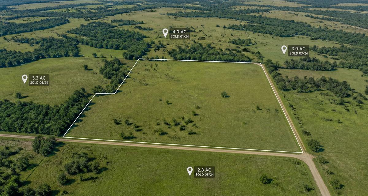
Valuing vacant land is harder than valuing a house. With a house, you can compare bedrooms, bathrooms, square footage, and condition against dozens of recent sales on the same street. With land, two parcels sitting side by side can differ in zoning, legal access, utility availability, terrain, flood exposure, soil suitability, development potential, restrictions, and permitted density — and those differences can move value by six figures.
That is why two parcels of similar size can be worth very different amounts.
This guide walks through the methods used to calculate land value, worked examples for each, the adjustments that separate a credible estimate from a guess, and the mistakes that most often produce a bad number. Everything here produces an estimate based on verified information — not a guaranteed sales price, and not an appraisal.
If you want to work through a structured version of this while you read, the LandGauge Value Estimator organizes the same inputs described below.
1. What determines the value of vacant land?
Land value is the market's read on what can realistically be done with a parcel, how quickly, and at what cost. The factors that drive it most:
- Location — market, submarket, school district, commute patterns, and the direction of local growth
- Parcel size and dimensions — total area, width, depth, and whether the shape supports a usable building envelope
- Legal and physical access — a recorded right to reach the parcel, plus a route that physically exists
- Zoning and allowed uses — the district, overlays, conditional uses, and density permitted
- Utility availability and connection costs — power, water, sewer, and gas, priced by real extension distance and capacity
- Topography and slope — grading cost, retaining walls, and how much area is practically developable
- Flood zones and wetlands — mapped constraints that affect buildability, insurance, and permitting
- Soil and septic suitability — where sewer is unavailable, septic feasibility can decide whether the parcel is buildable at all
- Buildable area — the usable portion after setbacks, easements, slope, and constrained areas are removed
- Subdivision potential — whether additional lots are realistically achievable under local standards
- Easements, restrictions, and encumbrances — utility easements, road agreements, covenants, and encroachments
- Road frontage — the amount and quality of frontage on a maintained road
- Market demand — absorption for finished lots or homes in that price band
- Nearby development and employment — new subdivisions, infrastructure, and job growth
- Holding and development costs — taxes, financing, engineering, permitting, and time
A listing that says "utilities nearby," "buildable," or "development potential" is describing a possibility, not a fact. A claim is not verification. Treat every one of those phrases as an open question until a utility provider, planning department, recorded document, or qualified professional confirms it. Requirements vary by jurisdiction, so confirm specifics with the relevant county, city, utility provider, or recorded documents.
2. The comparable-sales method
For most residential vacant land, comparable sales are the most practical starting point. You are answering a narrow question: what have buyers actually paid recently for parcels like this one?
Selecting useful comparables
- Similar location and submarket
- Similar parcel size
- Similar zoning and allowed use
- Similar utility status
- Similar access
- Similar terrain
- Similar development potential
- Recent closed sales, not just active listings
Active listings tell you what sellers hope to get. Closed sales tell you what buyers were willing to pay and what a lender or cash buyer was willing to support. Use listings for market direction; build the estimate from closings.
A simple example
- Comparable 1: 0.20 acres sold for $68,000
- Comparable 2: 0.18 acres sold for $72,000
- Comparable 3: 0.22 acres sold for $75,000
Initial indicated range: approximately $68,000–$75,000.
That range is a starting point, not a conclusion. If Comparable 2 had sewer at the frontage and the subject parcel requires septic, or Comparable 3 had a paved public road and the subject relies on an unrecorded dirt track, the raw range overstates the subject's value. Adjustments are covered in section 7.
For the mechanics of sourcing comps, see How to Find Land Comps for Vacant Land.
3. The price-per-acre method
The calculation is straightforward:
Example:
- Comparable sale: 5 acres sold for $100,000
- Price per acre: $20,000
- Subject parcel: 8 acres
- Preliminary value: $160,000
The trap in this method is scale. Price per acre almost always declines as parcel size increases, because larger tracts have a smaller buyer pool, longer absorption, and higher carrying cost. A $20,000-per-acre figure derived from a five-acre sale should not be applied to a 100-acre tract without a size adjustment — doing so can overstate value dramatically.
Price per acre works best for:
- Rural residential land
- Agricultural land
- Recreational land
- Larger development tracts
Match the comp's acreage band to the subject's acreage band before you divide.
4. The price-per-square-foot method
For small residential lots and infill parcels, square footage is usually the unit the market actually trades on.
Example:
- Lot size: 7,500 square feet
- Market indication: $9.50 per square foot
- Preliminary value: $71,250
A buildable, fully serviced lot — power, water, and sewer available, legal access confirmed, level, and within a district that permits the intended use — can command substantially more per square foot than an unserviced or constrained parcel in the same neighborhood. The unit price is a shorthand for everything that has already been resolved on the serviced lot.
5. Development or subdivision value
Developers frequently work backward from the finished product. Instead of asking what the dirt is worth today, they ask what the completed lots or homes will sell for, subtract everything required to get there, and treat what remains as the amount available to pay for the land.
Simplified example:
- 20 potential finished lots
- Estimated finished lot value: $60,000 each
- Total projected lot revenue: $1,200,000
- Roads, utilities, engineering, permits, financing, sales, and contingency: $700,000
- Required developer margin and risk allowance: $250,000
- Preliminary residual land value: $250,000
Everything in that calculation depends on the lot count being real. A conceptual yield drawn on a map is not an approved yield. Before treating 20 lots as achievable, verify zoning and minimum lot size, road design and width standards, utility capacity and extension requirements, drainage and stormwater requirements, setbacks and frontage minimums, topography and usable area, and the local approval process and timeline. Any one of those can reduce the count — and a reduction from 20 lots to 16 changes the residual figure far more than most people expect.
Work through How to Know if Land Can Be Subdivided before relying on a development-based value.
6. The income approach
Some land produces income, and that income can support value independent of a future sale. Common examples:
- Agricultural leases
- Grazing leases
- Timber
- Parking
- Storage
- Renewable-energy leases
- Commercial ground leases
An income-based estimate should account for vacancy, operating expenses, lease term and renewal risk, the creditworthiness of the tenant, and an appropriate capitalization rate for that use and market. Lease documents govern — read them rather than relying on a summary.
7. Adjusting comparable land sales
Adjustment is where a rough range becomes a defensible one. You are asking, factor by factor, whether the subject parcel is better or worse than each comparable.
Reasons for an upward adjustment
- Confirmed legal access
- Public water and sewer available
- Power at the property
- Favorable zoning for the intended use
- Level terrain
- Strong road frontage
- A verified buildable area
- Approved subdivision entitlements
Reasons for a downward adjustment
- No legal access
- Expensive utility extensions
- Steep terrain
- Floodplain or wetland constraints
- Septic limitations
- Irregular dimensions
- Easements or encroachments
- Demolition or debris removal costs
- Unverified development claims
| Factor | Subject parcel | Comparable parcel | Likely adjustment |
|---|---|---|---|
| Access | Confirmed public road | Private road, status unclear | Subject may be worth more |
| Sewer | Available at frontage | Septic required | Subject may be worth more |
| Terrain | Mostly level | Steep slope | Subject may be worth more |
| Zoning | Residential | Residential | Little or no adjustment |
Keep adjustments explainable. If you cannot state the reason and the source for an adjustment in one sentence, it is a guess. The land-comp adjustment guide goes deeper on sizing each one.
8. Asking price versus market value
Five numbers get confused constantly:
- Asking price — what a seller is requesting today
- Assessed value — the county's figure for property taxation
- Appraised value — a licensed appraiser's opinion of value, prepared to a professional standard
- Estimated market value — your researched estimate of what the parcel would likely trade for
- Closed sale price — what a buyer actually paid
County assessed value is used primarily for taxation. It is often produced through mass appraisal and may lag the market in either direction, so it is not a substitute for a market estimate. Confirm assessment methodology and appeal deadlines with the county assessor.
Online automated estimates can provide useful context and a starting range, but they generally cannot see parcel-specific access rights, utility connection costs, zoning overlays, topography, or buildability. Those are exactly the factors that separate two similarly sized parcels — see Why Two Pieces of Land Have Different Values.
9. Common land-valuation mistakes
- Using active listings as if they were closed sales
- Comparing parcels with different utility conditions
- Ignoring legal access
- Valuing the entire acreage as if all of it were buildable
- Assuming subdivision potential without reviewing local standards
- Applying one price-per-acre figure to every parcel size
- Ignoring development and connection costs
- Relying only on county assessed value
- Failing to verify easements and restrictions
- Treating an estimated value as a guaranteed sale price
Most of these share one root cause: a claim was accepted as a fact. Verify Before You Rely.
10. A practical land-valuation process
- Identify the parcel and confirm acreage from county records rather than the listing
- Review zoning and allowed uses, including overlays and conditional-use requirements — see how to verify zoning on land
- Verify legal and physical access through recorded documents — see the access guide
- Determine utility availability and likely connection costs with each provider — see the utilities guide
- Review flood, wetlands, slope, soils, and other constraints, and confirm what remains buildable
- Identify recent comparable closed sales
- Normalize the comparables by acre, square foot, lot, or development unit
- Adjust for meaningful differences between the comps and the subject
- Estimate a reasonable value range
- Document assumptions, sources, unanswered questions, and next actions
A range is usually more defensible than a single number. A range communicates what is still unknown; a single figure implies a precision that early-stage land research rarely supports. As items get verified, the range narrows. You can run steps 6 through 9 inside the LandGauge Value Estimator and keep the supporting notes with the parcel.
For the broader framework on how value changes as a parcel moves from unresearched to builder-ready, see What Is Land Worth: Raw, Builder-Ready, Subdivided and How to Estimate Vacant Land Value.
11. How LandGauge helps organize the valuation process
LandGauge is a research and underwriting workspace. It helps you:
- Record comparable sales in one place
- Track source links, documents, and the contacts who confirmed each answer
- Separate verified facts from assumptions
- Document utility, access, zoning, and site constraints
- Estimate a likely parcel value range
- Identify the questions that are still unanswered
- Preserve photos, field notes, costs, and supporting evidence
- Review how new information changes the preliminary estimate
LandGauge does not replace an appraiser, broker, engineer, attorney, surveyor, title professional, or government agency, and it does not produce a certified appraisal. It organizes the investigation so the estimate you rely on is traceable back to something you actually verified.
Take the Guess Out of the Deal. Start with a value range, document what supports it, and keep narrowing it as answers come in.
Frequently asked questions
Related guides
- Land Value & CompsHow to Find Land Comps for Vacant LandPull realistic comps, avoid misleading per-acre averages, and decide whether a deal is priced realistically.
- Land Value & CompsHow to Estimate Vacant Land ValueCompare comps, price-per-acre ranges, zoning, and buildability so the asking price actually holds up.
- Land Value & CompsHow to Adjust Land Comps for Access, Utilities, Zoning, and BuildabilityDecide whether a comparable land sale is genuinely comparable — access, utilities, zoning, usable acreage, wastewater, flood risk, and development potential — before entering it into the Vacant Land Value Estimator.
- Lot SplitsHow to Know If Land Can Be SubdividedFrontage, minimum lot size, access, and utilities — the four questions that decide every split.