Is Your Existing Survey Enough Before Developing or Subdividing Land?
Before developing or subdividing land, learn how to judge whether an existing survey is sufficient—using a real anonymized fence-versus-boundary example.
Before buying land to develop or subdivide, ask a licensed surveyor whether the existing survey is sufficient for your intended use. Older surveys can be valuable, and age or the absence of GPS does not by itself invalidate a survey. Sufficiency depends on the document's scope, available records, changes on the ground, your proposed work, and local requirements—subject to professional review.
Before buying land to develop or subdivide, ask a licensed surveyor whether the existing survey is sufficient for your intended use. Older surveys can be valuable. Age or the absence of GPS does not by itself invalidate a survey. Sufficiency depends on the document's scope, the records available, changes on the ground, the work you propose, and local requirements—subject to professional review.
Watch: A Fence Line vs. the Surveyed Boundary
A short walkthrough of an anonymized survey excerpt where the existing fence and the surveyed boundary line differ at two marked locations. Educational example, not a boundary determination.
Open the video directlyA Boundary Survey and a Design Survey Are Different Tools
An existing boundary survey answers the question it was commissioned for: where the surveyed boundary lines and corners are, based on the records and fieldwork available at the time. A topographic or design survey serves a different purpose by capturing elevations and site features for engineering. A subdivision survey and plat document proposed or approved new lots under the applicable local process; approval and recording requirements must be confirmed locally.
That means a new project can require additional fieldwork or information even when the existing survey remains useful. Avoid two blanket assumptions: that any old survey is worthless, and that any existing survey is automatically enough. Neither is true without reviewing the document's scope against what you intend to do.
A Real Example: The Fence and the Boundary Disagree
The excerpts below come from a survey of an inherited property being considered for future development. The family already owned the land; the survey was reviewed as part of planning, not discovered after a purchase. Names, location, and the surveyor's identity are removed.
The survey's own legend defines the two symbols that matter here:


At two separate marked locations, the existing fence line and the surveyed boundary line differ—by 17.54 feet at the north location and 37.85 feet at the south location:
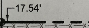
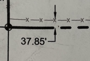
Read this carefully. A gap between a fence and a surveyed boundary is a discrepancy worth investigating. It is not automatic proof of a legal defect or a determination of ownership or how the fence should be handled. Fences are built for many reasons—convenience, livestock, terrain—and occupation lines and record boundary lines commonly differ. The excerpt shows that the fence and surveyed boundary do not match; ask the surveyor how that affects your proposed layout.
Also note what this example cannot tell you. Two offset measurements at two points do not let you compute a lost area, and a photographed or resized excerpt is not a measurement scale. Those questions belong to the surveyor with the full drawing and records.
Hypothetical Purchase Example
Now consider a different, hypothetical situation—this did not happen on the inherited property above. A buyer intends to split a parcel into two lots and sketches the layout using the fence line visible during the site visit. During professional review before closing, the survey shows the fence is offset from the surveyed boundary. The buyer's assumed building envelopes, setbacks, and frontage were measured from the wrong line, and the layout assumptions have to be revisited before committing.
Identifying the mismatch early gives the buyer time to investigate its effect on the proposed layout, budget, and timeline before making further commitments. The cost and difficulty depend on the circumstances.
What to Verify in an Existing Survey
- Fence and occupation mismatch. Where physical occupation (fences, driveways, improvements) differs from the surveyed boundary, flag it for the surveyor rather than resolving it yourself.
- Corners and monuments. Note corners that are unclear, missing, or disturbed. Never move, reset, or remove a survey monument yourself.
- Access location and rights. Compare the physical road or driveway with the recorded access or easement location, and have intended-use rights reviewed by the appropriate title professional, attorney, or agency.
- Completeness. Confirm you have every sheet, the notes, and the legal description—and whether the detail captured matches what your project needs.
- GIS and phone location. County GIS and a phone pin are research references, not boundary determinations.
Potential Impacts If the Survey Is Not Sufficient
| Area | How an insufficient survey can affect it |
|---|---|
| Layout | Setbacks, frontage, and building footprints measured from the wrong line |
| Budget | Additional survey, engineering, or professional review costs you had not planned |
| Timing | Depending on circumstances, closing or development steps may be affected |
| Title | Coverage depends on your actual policy terms, endorsements, exclusions, and exceptions |
On title insurance specifically: never assume a discrepancy is covered. Ask your title provider about the specific issue and what your policy's terms, endorsements, exclusions, and exceptions say. The Washington Office of the Insurance Commissioner's consumer guidance illustrates the kind of questions to ask your insurer about policy exclusions; it is consumer guidance, not a Washington-specific requirement that applies elsewhere.
Professional Review Comes First
Do not move or tear down a fence before professional review. The Idaho Division of Occupational and Professional Licenses' engineers and land surveyors FAQ offers professional guidance on surveying, corners and monuments, and the review of discrepancies; it is Idaho-specific guidance, not a nationwide rule, and the board's statutes, rules, and guidance page is the place to confirm current professional land surveyor requirements there. Confirm the rules where your property is located.
Questions to ask a licensed surveyor:
- Is this the complete survey—all sheets—and are the current records available?
- Is its scope sufficient for a purchase, a build, or a subdivision?
- Is retracement, corner recovery, topographic work, or other additional fieldwork needed?
- Can you explain the legend, the offsets shown, and the site conditions?
- What deliverables does the local plat or subdivision process require?
- Can I get a written scope, cost, and timing before work begins?
Other appropriate local professionals have separate roles: the planning authority confirms requirements, an engineer handles layout and design, and a title professional or qualified local attorney addresses rights, access, and title questions. For transactions where a lender or title insurer requires it, ALTA's land title survey standards address boundaries, access, easements, and related survey matters—but that is a specialized transaction scope, not a requirement for every land purchase.
Practical Checklist Before You Commit
- Gather the full survey, deed, easements, and any recorded plat.
- Describe your intended use to each professional you consult.
- Compare observed features against the survey without trying to locate your own boundary.
- Log each discrepancy with its source, date, and photos.
- Ask the relevant professionals and agency the questions above.
- Budget money and time for the confirmed next steps—not guessed ones.
LandGauge helps you organize the documents, the unknowns, and each professional confirmation in one place. It does not determine boundaries or legal rights.
Start a Property Analysis or work through the Land Due Diligence Checklist. To go further on reading the document itself, see How to Read a Land Survey and Who Pays for a Property Survey—Buyer or Seller?. For the surrounding research, continue with How to Read a Plat Map, Can You Split Land Into Two Lots?, and How to Find a Deed, Plat, or Recorded Easement.
Verify Before You Rely.
Frequently asked questions
Sources & Official Resources
Primary sources that support the information in this guide. Requirements and record systems vary by jurisdiction — always confirm with the agency responsible where the property is located.
- Idaho Division of Occupational and Professional LicensesProfessional Engineers and Land Surveyors — FAQ
Professional guidance on surveying, corners and monuments, and review of discrepancies. Idaho-specific; confirm the rules where your property is located.
- Idaho Division of Occupational and Professional LicensesStatutes, Rules, and Guidance
Source for current professional land surveyor requirements and guidance in Idaho; other states have their own boards and rules.
- American Land Title AssociationALTA/NSPS Land Title Survey Standards
Land title survey standards addressing boundaries, access, easements, and related survey matters for title and lender requirements—a specialized transaction scope, not a requirement for every land purchase.
- Washington Office of the Insurance CommissionerTitle Insurance — Consumer Guidance
Consumer guidance on asking your insurer about policy exclusions. Not a Washington-specific requirement generalized to other states.
Related guides
- Due DiligenceHow to Read a Land Survey: Boundaries, Notes & AccessLearn how to read a land survey: identify parcel boundaries, understand surveyor notes, and investigate the road shown before relying on access claims.
- Due DiligenceWho Pays for a Property Survey—Buyer or Seller?Who pays for a property survey depends on why it is needed. Compare buyer due diligence, seller-created parcel splits, owner development costs, and negotiated exceptions.
- Due DiligenceHow to Research Land Before Buying: A Practical GuideSame Questions. Different Timeline.
- Due DiligenceWhich Land Research Tool Do You Need? Maps, Property Records and Due Diligence ComparedCompare LandGauge, Land id, Acres, Regrid, LandGlide, AcreValue and PropStream by task, published features and pricing. Choose tools for your land research.