Does Residential Zoning Mean You Can Build a House?
A residential zoning label is only one part of the answer. Separate allowed use, lot eligibility, and project approvals before relying on a vacant-land listing.
No—not by itself. Residential zoning does not establish that a particular vacant lot can support your house or that the project has the approvals needed to proceed. It is one part of the answer, not the finished answer.
A listing says “residential.” The county map shows a residential district. There are houses down the road. It is tempting to turn those clues into a simple conclusion: I can build here.
Before you do, separate three questions: Is this use allowed? Is this lot eligible for the proposed development? Has this project received the required approvals? A yes to one does not supply the answers to the others.
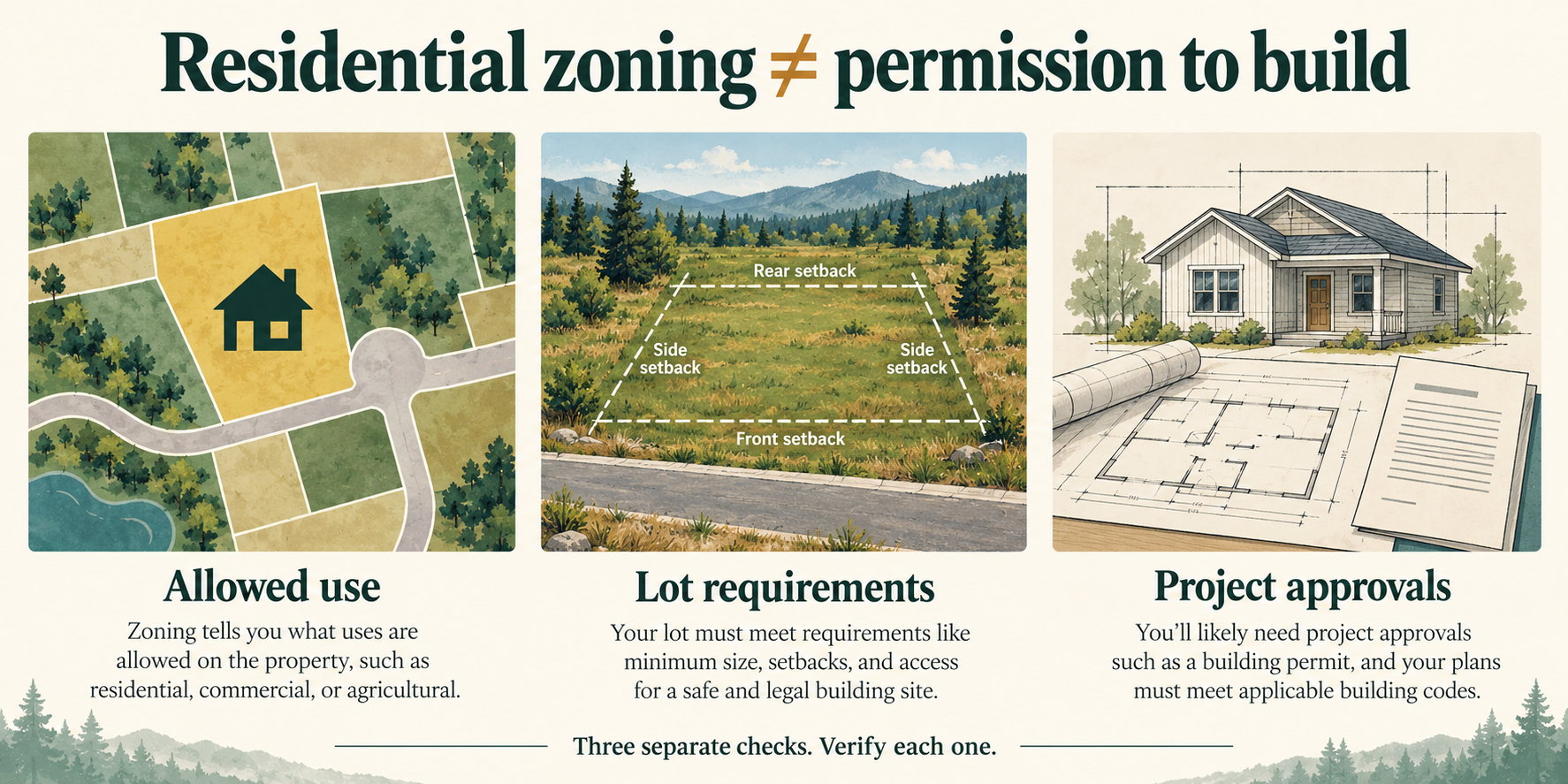
1. Allowed use: what does “residential” actually mean here?
Start with the house you intend to build, not just the word on the listing. Describe the proposed home type, number of dwellings, and any other intended use. Then ask the responsible planning authority which current district and rules apply to the exact parcel.
The useful answer is not merely “residential zoning.” It is an answer about your proposed use under the applicable ordinance: whether it is allowed, subject to a separate review, or not allowed as proposed.
If you still need to find the designation and ordinance, use How to Verify Zoning on Land. This guide starts with the next question: what can you reasonably conclude once you have that information?
A zoning designation is evidence to interpret. It is not a building permit.
2. Lot eligibility: does the answer apply to this particular parcel?
Even if the proposed use is allowed in the district, the parcel still needs its own investigation. Ask whether it is a lawful lot for the intended development and which dimensional requirements, restrictions, or site conditions remain unresolved.
For example, Bonner County, Idaho’s planning FAQ explains that legal parcel status is only one factor in buildability. It identifies setbacks, density, easements, protected natural features, and other agencies’ restrictions as additional considerations. That is a local example, not a nationwide approval standard.
The distinction matters when someone says, “It has its own parcel number,” or “It is already on a recorded plat.” Keep the documents, but ask the responsible authority what they establish for the development you have in mind. Do not fill a missing answer with an assumption.
This is where zoning interpretation connects to the larger buildability investigation. Access, wastewater, utilities, and physical constraints deserve their own evidence rather than being treated as settled by a residential label.
3. Project approvals: what has actually been approved?
A general answer about an allowed use is different from approval of a particular proposal. Ask which plans, applications, agency reviews, and permits apply before work begins. If the seller mentions an approval, obtain the actual record and check its scope and conditions with the issuing authority.
Fairfax County, Virginia’s residential new-building guidance, for example, requires a new-building permit for a new single-family dwelling. Its process can involve zoning, building, site, health, and other reviews. Those are Fairfax requirements; your property’s authorities and process may differ.
When you receive an answer, record what it covers. “The district allows this use” and “this project has an issued permit” should never become the same note.
What each finding tells you—and what it leaves open
| What you found | What to record | What remains a separate question |
|---|---|---|
| A residential designation on a map | District, map source, date, and parcel match | Does the current ordinance allow your specific use? |
| An answer that the use is allowed | Source, applicable provision, and any qualifications | Does this lot meet the applicable requirements? |
| A lot-status or site-related determination | The actual document and its scope | Which other conditions and project reviews remain? |
| An approval or permit | Issuing authority, approved plans, and conditions | What work does it authorize, and what else is required? |
Use the table to avoid giving evidence more weight than it can carry. It is a way to organize the investigation, not an approval sequence that every jurisdiction follows.
Example: one residential lot, three different answers
Imagine a vacant parcel advertised as “residential—ready for your dream home.” This is a hypothetical example, not a reviewed property.
The buyer confirms that the applicable district allows the proposed type of house. That resolves one question. It does not resolve whether the proposed house fits the lot or whether the wastewater plan is acceptable.
The buyer then learns that an easement may affect the intended building location. A qualified professional needs to review the documents and proposed layout. Wastewater feasibility also remains unanswered. No project permit has been issued.
The useful conclusion is not “buildable” or “unbuildable.” It is: the proposed use appears supported by the zoning information obtained; layout, wastewater, and project approvals still need verification.
That more precise description helps the buyer decide what to investigate next without pretending the decision is already made.
Turn the zoning answer into a next step
Need the starting sources? Open LandGauge’s Research Hub for parcel and zoning research resources. Prepare your parcel identifier, intended use, source documents, and unresolved questions before contacting the governing office. Use What to Ask the Planning Office Before Buying Vacant Land to prepare that conversation, and the land due diligence checklist to keep other categories from disappearing behind the zoning question.
Start a LandGauge Property Review to keep the intended use, source links, and unanswered questions with the property. Begin with what you want to do, then use the due-diligence workflow to organize what still needs checking. Saving an intended use does not establish permission for it.
LandGauge organizes your research; it does not issue a zoning determination or guarantee buildability, service, or permits. Confirm property-specific conclusions with the responsible authorities and qualified professionals.
Residential zoning starts a question. It does not finish the investigation.
Related guides
- ZoningWhat to Ask the Planning Office Before Buying Vacant LandFound your parcel on GIS? Here’s what to verify next.
- ZoningHow to Research ZoningZoning determines what you can build. Reading code carefully is faster than learning by denial.
- ZoningHow to Verify Zoning on LandWhere to look up zoning, how to read the ordinance, and what questions to ask the planner.